Welcome to the third installment of my journey to the Northwest Coast. Time to hit the road! Below is the route I took from SEATTLE to CAPE FLATTERY (the most Northwest point of the continental US)!
A major part of the fun for me was going places I've never been to before...there were always surprises just around the next bend in the road! I think there is a saying that goes something like: "The Journey is the Destination". (If there isn't...I just made that up, and you have to pay me a dollar every time you say it.)
The next few photos are of things that just caught my eye, and made me pull the car over. I loved seeing all the little towns and ports along the way. Below is PORT GAMBLE...sure would have enjoyed sketching that logging stuff if I had the time!
Next are a few shots of PORT ANGELES.
These beautiful views are of LAKE CRESCENT.
So much of the pleasure of this trip was driving up and down very steep and curvy roads. On every side there were lush forests of evergreens and ferns. A good portion of the route I took went through the OLYMPIC NATIONAL PARK...more to explore another time!
Now I don't want you to think it was ALL a lovely drive. There was a stretch of the road that had several crews laying new asphalt down...black tar...loose gravel...dust...and LOTS of waiting for our turn to follow the little "Pilot Car" down one lane of the highway. Probably added a least an extra hour to my drive-time.
Next up...a FISH IN A BRA! I just had to get a pic of this amusing wood-carving watching over the little town of SEKIU.
As I rounded a curve, I saw this interesting "Backyard Boulder". I thought it would be cool to have that behind your house. Actually, it's part of a lodge at CHICO BEACH.
This is the last port before reaching the end of the road...NEAH BAY.
Made it!! Here's the path that will take you to see the views of CAPE FLATTERY. It's a very steep walk downhill...had to take lots of stops to catch my breath on the climb back up to my car. I thought it interesting how "indecisive" some of the trees were..."Do I grow down?...er...no...UP! Yeah, that's where I want to go...UP!"
This is the first observation point you come to...gorgeous! The fog made it quite magical.
According to Wikipedia: Cape Flattery is the oldest permanently named feature in Washington state, being described and named by JAMES COOK on March 22, 1778. Cook wrote: "... there appeared to be a small opening which flattered us with the hopes of finding an harbour ... On this account I called the point of land to the north of it Cape Flattery."
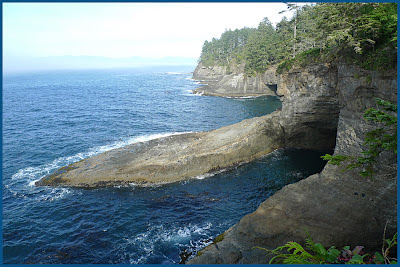
A bit farther down the trail, looking back southward to the cove that I just showed pics of...the water was an incredible blue green...mesmerizing!
This is the farthest point on the trail...I'm looking west towards TATOOSH ISLAND. Unfortunately, the fog prevented me from seeing the lighthouse. I borrowed a photo from Wiki that shows what I missed.
These are the waves crashing directly below that little tree...the colors seemed unreal!
While the fog was so thick on the westward side of the cape...you could make a quarter turn to the right and look north towards VANCOUVER ISLAND (hidden in the fog...but I'm pretty sure I could hear Canadians speaking French). There it was...SUNSHINE on the rocky shore!
That's all for now! Next time...on to the land of "TWILIGHT"...FORKS, WA.


2 comments:
STUNNING photos, Warren!
Thank you, Cathy...it's a dreamworld out there...hard not to take pics that look good.
Post a Comment